
From Static Maps to Smart Systems: How GIS, LiDAR and Geospatial AI are Reshaping Utility Inspections

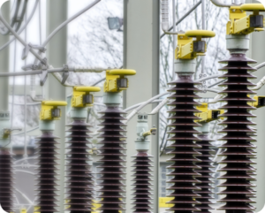
Visual inspections of the power grid have traditionally relied on manual methods and reactive responses. These inspections, whether performed on foot, by helicopter or drone, often involve fragmented data systems and delayed reporting cycles. The approach worked for decades, but it is no longer sufficient.
Utilities are now facing intensified pressure on several fronts. Infrastructure is aging faster than it is being replaced. Wildfires, storms, and extreme temperatures are more frequent. Electrification is accelerating through electric vehicles, rooftop solar, and distributed energy. The demands placed on grid reliability and safety are increasing in both frequency and complexity.
In response, inspection strategies are shifting. What once relied solely on human observation is being replaced by digital workflows, remote sensors, and machine learning. The convergence of drones, LiDAR, thermal imaging, GIS platforms, cloud computing and artificial intelligence is producing a new model of infrastructure inspection. This model is faster, more scalable, and inherently more predictive.
Understanding Grid Infrastructure as a Geospatial SystemTransmission and distribution networks are not isolated or linear. Every pole, substation, and conductor exists in a geospatial context. Topography, vegetation, population density, and climate risks all influence asset health and risk.
Geographic Information Systems provide the foundation to understand these assets in context. Rather than treating inspections as a collection of images, GIS enables utilities to construct digital twins of their infrastructure. These systems allow each structure to be precisely mapped, layered with environmental and operational data, and linked to inspection findings.
These digital twins function best when anchored in a broader Spatial Data Infrastructure (SDI) that supports interoperability across platforms like ArcGIS, SCADA, and DERMs. This allows fault detections to be analyzed not just as isolated events, but as operational risks influenced by real-time telemetry, topography, and historical performance patterns.
Industry leaders such as ESRI continue to push the boundaries of what’s possible with GIS-driven utility analytics, making it easier to link inspection data with environmental, operational, and geospatial intelligence in real time.
By anchoring inspection data to real-world coordinates, teams can track degradation over time, identify spatial clusters of risk, and allocate resources with greater precision. Integrating inspections into a GIS workflow is especially critical because any actions resulting from inspections, such as issuing work orders, depend on having accurate location data. Grounding inspection workflows in the physical reality of the grid not only improves organization, it ensures that insights can be acted upon efficiently and accurately.
LiDAR, Thermal, and Multispectral Sensors Reveal the HiddenTraditional images provide important surface-level information. However, to gain a complete view of asset health, more advanced sensing is required.
LiDAR delivers high-resolution, three-dimensional models of terrain and infrastructure. It can identify slight pole shifts, structural deformation, and vegetation surveys. Thermal sensors identify hotspots on insulators, conductors, or transformers that may signal pending failure. In dry or fire-prone regions, this information is critical for preventive action.
One recent example is the New York Power Authority’s investment of over 37 million dollars into drone-based inspection and remote sensing capabilities. This level of investment signals growing industry-wide recognition of the value in seeing beyond the visible spectrum.
From Data Collection to Predictive Insight with Geospatial AIDrones and sensors generate immense volumes of data. Analyzing these data sets quickly and accurately requires machine learning. Computer vision models can now detect over dozens fault types: including rust, broken insulators, vegetation risks, and hairline cracks, often with precision levels above 85 percent. This dramatically exceeds what is possible through manual analysis alone.
Once detections are geolocated, advanced Geospatial AI (GeoAI) techniques such as semantic segmentation, spatial transformers, and NDVI (Normalized Difference Vegetation Index) can identify deeper patterns across assets and environmental zones. These outputs can be directly integrated into GIS environments, enabling teams to visualize faults in spatial context and prioritize mitigation based on risk proximity.
Spatiotemporal clustering models can help forecast high-probability failure zones by analyzing degradation trends across time and geography, pushing inspections toward predictive rather than reactive workflows. This transition represents more than automation. It introduces a spatial logic to inspection planning, moving the process from one of isolated checks to one of continuous, geospatial awareness.
Structure-Based Workflows Replace Fragmented Data HandlingHistorically, inspection images were linked to structures/assets manually, requiring analysts to match each image to its location, a process that was slow and prone to errors. Today, that connection is made automatically, streamlining workflows, reducing delays, and improving accuracy.
Structure-based inspection systems change this model. Asset lists can be imported from GIS databases or spreadsheets. Each image, annotation, and AI detection is automatically linked to the corresponding pole, tower, or substation.
This transforms inspections into dynamic, intelligent asset records. Infrastructure teams can triage issues by location, monitor asset condition longitudinally, and integrate findings directly into maintenance, work order and asset management systems. The result is a faster, more reliable, and more scalable process.
Human-in-the-Loop AI Enhances Trust and AccuracyEven the most advanced models require human oversight. Subject-matter experts play a critical role in validating AI outputs, correcting false positives, and refining labels. This process is not a limitation but a strength.
With every feedback loop, AI models learn and improve. Over time, they become more aligned and personalized with the specific characteristics of a utility’s infrastructure and environment. Enhanced review tools, such as polygon-based annotation and label filtering, streamline this process and help maintain clarity in decision-making.
The combination of artificial and human intelligence ensures not only accuracy, but also transparency. It builds confidence in the system for field engineers, analysts, and leadership alike.
Lowering the Barrier for Smaller UtilitiesWhile the largest utilities may already operate advanced inspection systems, many smaller operators face constraints in budget, staffing, and digital infrastructure. Scalable tools now allow these organizations to begin with image ingestion, GIS mapping, and manual tagging, then layer on automation over time.
This graduated approach supports incremental modernization. Enabling early gains in operational visibility and inspection speed, while establishing a clear path to fully AI-enabled inspection intelligence.
The Future of Inspection is Spatial, Predictive, and ContinuousIn the coming years, inspection technology will continue to evolve. Synthetic data will allow AI to recognize rare but high-impact events, such as wildfires or arc flashes. GIS platforms will support two-way integration, allowing inspection results to trigger work orders automatically. Drones and satellites will work together to provide layered, regional views of grid performance and environmental exposure.
Inspection will no longer be a snapshot in time. It will be a continuous, spatially aware process that combines visual intelligence with environmental and operational data to anticipate failure before it occurs.
The shift from static maps to smart systems is already underway. What lies ahead is a more resilient, data-informed grid that can withstand the challenges of an electrified, climate-impacted world.
—Vikhyat Chaudhry is co-founder and CTO/COO for Buzz Solutions.
powermag


